Your cart is empty


Tropical cyclones
Cyclones are large air masses with winds spiralling inwards around a low-pressure centre, and carry clouds and precipitation.
Geography
Grades 7 – 12
Keywords
mozaLink
/Weblink
Scenes

Tropical cyclones
- Arctic Circle
- Tropic of Cancer
- Equator
- Tropic of Capricorn
- Antarctic Circle
- South Pole
- North Pole
- dominant air flow
Tropical cyclones are amongst the most destructive weather phenomena. They form exclusively over tropical seas and oceans, usually between 10 and 20 degrees latitude.
Each year, around 50 tropical cyclones form on the Earth; from May to November in the Northern Hemisphere and from November to May in the Southern Hemisphere. Their names are assigned in alphabetical order. Previously, they were only given female names, but nowadays male names are also used. One of the best-known recent tropical cyclones was Hurricane Katrina, which brought devastating damage to the city of New Orleans in 2005.
A tropical cyclone is a rapidly rotating, strong wind system characterised by an extremely low-pressure centre. A tropical cyclone is made up of spiral bands, or a spiral of clouds. The density of these clouds is the highest around the eye, where the converging spiral bands meet.
Definitions of terms:
Cyclone: a low-pressure atmospheric formation (with pressure decreasing towards the centre) characterised by inward-spiralling winds that blow counterclockwise in the Northern Hemisphere. The air gathered in its centre moves upwards.
Typhoon: tropical cyclone formed above the Pacific Ocean.
Hurricane: tropical cyclone formed above the Atlantic Ocean.
There is no special term for tropical cyclones formed above the Indian Ocean, they are simply called tropical cylcones.

Cyclone
- eye - The area with the lowest air pressure. A wind- and cloud-free area with a diameter of several kilometres to hundreds of kilometres.
- inflow
Many cyclones are formed in the tropical region, above the thermal equator. In this region, warm air rises so fast that it starts to swirl. When a vortex breaks free, it can become a tropical cyclone.
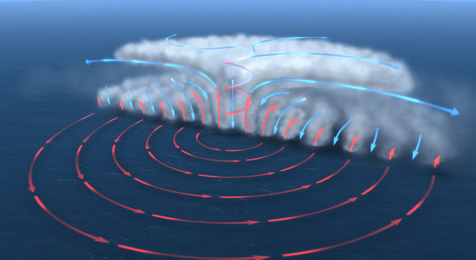
In cyclones, the air spirals inwards, in a counterclockwise direction in the Northern Hemisphere, and a clockwise direction in the Southern Hemisphere. Air gets very dense inside and it can only move upwards. As the warm air moves upwards fast, it cools down rapidly, its vapour content condenses, thus clouds and precipitation are formed.
Above the ocean, the lower layer of the atmosphere warms up and then rises. The rising air causes a low-pressure area to develop at surface level. Air spirals inward anticlockwise in the Northern Hemisphere and clockwise in the Southern Hemisphere, due to the Coriolis effect.
The air rising in the centre of the cyclone spreads horizontally in the troposphere. Since this rising air is warmer than its surroundings, the cold air descends in the centre, and a cloud-free area, known as the eye of the cyclone, is formed.
Tropical cyclones not only spin above one spot, but also move westward. Although the wind is very intense inside cyclones, their progress is relatively slow.

Cross section
- low air pressure
- high air pressure
- rising warm air
- outflow
- descending cold air
- heavy rainfall
- eye
- eyewall
- inflow
In the tropical zone, sea surface temperature is highest in late summer. Warm water evaporates, rises and transfers some of its energy to the atmosphere, thus, forming thunderstorms. The wind blowing from the inside of the thunderstorm gathers air, forming an even larger thunderstorm cluster.
As the cluster grows in size, it can gather air from further areas as well. Due to the Coriolis effect caused by the Earth's rotation, the air gathered starts to swirl. As a result of this swirling motion, air pressure drops in the centre of the thunderstorm. If the cluster lasts long enough, the swirling motion becomes faster, and a thick cloud layer forms around the centre. Then, the eye of the cyclone appears as well. This is when the cyclone becomes fully developed.

Formation
- area above the ocean with a temperature above 26 °C
- surface winds of various direction
- rising warm air
- descending cold air
- outflow
- 12–15km
- Coriolis effect
- fully-developed tropical cyclone
- eye

Path
- August to October
- June to October
- June to December
- June to November
- January to March
- Atlantic Ocean
- Pacific ocean
- Indian Ocean
Tropical cyclones can travel thousands of kilometres from their area of formation before they die out. These cyclones can last several weeks. The life cycle of cyclones depends on how long they stay over warm waters.
At the end of the first week, tropical cyclones are called tropical depressions, while at the end of the second week they turn into tropical storms. Usually, they become fully developed within 10–15 days. As tropical cyclones gain their energy from the heat of seawater, they lose their strength very rapidly when they reach the mainland – although they can still cause heavy rainfall. When they leave the tropical zone and enter the area of westerly winds, they lose more energy; however, they can remain in that particular area as a tropical storm for several days.

Strength
- days 1–5 tropical disturbance
- days 5–6 tropical depression
- days 7–9 tropical storm
- days 10–15 hurricane
- days 16–17 extratropical transition
- day 17 extratropical cyclone
- cold front
- warm front
- Atlantic Ocean
- North America
- South America
- Equator
- Tropic of Cancer
- Tropic of Capricorn
- NE trade winds
- westerly wind
- weather front
- Strength of Atlantic cyclones
- Sustained winds (km/h)
- Atlantic Ocean
- Indian Ocean
- Pacific Ocean
- Name
- Tropical depression
- Tropical storm
- Category 1 hurricane
- Category 2 hurricane
- Category 3 major hurricane
- Category 4 major hurricane
- Category 5 major hurricane
- Severe tropical storm
- Tropical cyclone
- Intense tropical cyclone
- Very intense tropical cyclone
- Typhoon
- Super typhoon
Cyclones can be categorised according to their intensity. However, there is no standard classification throughout the world, as different scales exist based on the area of formation. For example, cyclones formed above the Atlantic Ocean can be classified into five categories, based on the speed of the wind blowing in the eyewall. The flow is most intensive in the eyewall, so this is the most destructive part of the cyclone.
These devastating cyclones produce heavy precipitation. The amount of rainfall can rise to 500 mm a day. Because of their rotation, they can even raise ocean levels, causing floods along the coastline and thereby enormous damage.
Narration
Tropical cyclones are amongst the most destructive weather phenomena. They form exclusively over tropical seas and oceans, usually between 10 and 20 degrees latitude.
Each year, around 50 tropical cyclones form on the Earth; from May to November in the Northern Hemisphere and from November to May in the Southern Hemisphere. Their names are assigned in alphabetical order. Previously, they were only given female names, but nowadays male names are also used. One of the best-known recent tropical cyclones was Hurricane Katrina, which brought devastating damage to the city of New Orleans in 2005.
A tropical cyclone is a rapidly rotating, strong wind system characterised by an extremely low-pressure centre. A tropical cyclone is made up of spiral bands, or a spiral of clouds. The density of these clouds is the highest around the eye, where the converging spiral bands meet.
Tropical cyclones not only spin above one spot, but also move westward. Although the wind is very intense inside cyclones, their progress is relatively slow.
In the tropical zone, sea surface temperature is highest in late summer. Warm water evaporates, rises, and transfers some of its energy to the atmosphere, thus forming thunderstorms. The wind blowing from the inside of the thunderstorm gathers air, forming an even larger thunderstorm cluster.
As the cluster grows in size, it can gather air from further areas as well. Due to the Coriolis effect caused by the Earth's rotation, the air gathered starts to swirl. As a result of this swirling motion, air pressure drops in the centre of the thunderstorm. If the cluster lasts long enough, the swirling motion becomes faster, and a thick cloud layer forms around the centre. Then, the eye of the cyclone appears as well. This is when the cyclone becomes fully developed.
Above the ocean, the lower layer of the atmosphere warms up and then rises. The rising air causes a low-pressure area to develop at surface level. Air spirals inward anticlockwise in the Northern Hemisphere and clockwise in the Southern Hemisphere, due to the Coriolis effect.
The air rising in the centre of the cyclone spreads horizontally in the troposphere. Since this rising air is warmer than its surroundings, the cold air descends in the centre, and a cloud-free area, known as the eye of the cyclone, is formed.
Tropical cyclones can travel thousands of kilometres from their area of formation before they die out. These cyclones can last several weeks. The life cycle of cyclones depends on how long they stay over warm waters.
At the end of the first week, tropical cyclones are called tropical depressions, while at the end of the second week they turn into tropical storms. Usually, they become fully developed within 10–15 days. As tropical cyclones gain their energy from the heat of seawater, they lose their strength very rapidly when they reach the mainland – although they can still cause heavy rainfall. When they leave the tropical zone and enter the area of westerly winds, they lose more energy; however, they can remain in that particular area as a tropical storm for several days.
Cyclones can be categorised according to their intensity. However, there is no standard classification throughout the world, as different scales exist based on the area of formation. For example, cyclones formed above the Atlantic Ocean can be classified into five categories, based on the speed of the wind blowing in the eyewall. The flow is most intensive in the eyewall, so this is the most destructive part of the cyclone.
These devastating cyclones produce heavy precipitation. The amount of rainfall can rise to 500 mm a day. Because of their rotation, they can even raise ocean levels, causing floods along the coastline and thereby enormous damage.